This post concludes my 4-part series recapping my trip to Isle Royale National Park in September 2023.
9/8, 2:30 p.m., a picnic table at Rock Harbor.
We’re 1 ½ beers into our day. We ate lunch at the Greenstone Grill, rather than snack on what little nibbles we’ve got left. We are now well stocked on candy and books and a sixer of Keweenaw beer.
We got up this morning and skipped coffee. We got on the trail around 8:30 and were in Rock Harbor by noon. We are at Site 17, and it’s been a few hours so I do not know if we have neighbors in our campsite. Hopefully not, but I won’t be surprised if we do. Today the skies are sunny and bright. There are just a few clouds in the sky. The temperature is cool, but sunny spots make it all feel different. It feels very good to wash my hands. I mailed off postcards. The original four that I picked up in Houghton, and four more. To Aubs, Joe & Randi, Michael, Ryan and Dave’s parents. We have mashed potato dinner plans, and now all the candy you could want.
4:30 p.m. Site 17
The Ranger is here, but the hikers haven’t decamped yet. We’re expecting a melee when they do. Site 17 appears to be too small to share, so here’s hoping for our seclusion.
I hate to leave the island but I know that this is not a place that needs me even if I need it. We’ll be back, always.
5 p.m. Site 17, Rock Harbor
Candy, chips, and mashed potatoes for dinner. Also beer. The finest. I have started reading a new book from the shop. “National Parks and the Woman’s Voice: A History” by Polly Welts Kaufman. It’s the kind of book I like, with lots of citations and tiny print.
6:15 p.m. Camp
I suspect we may have a site all to ourselves tonight. Lucky us. The folks in the overflow site look cramped. We are well-provisioned with candy and chips. Mashed potato and chicken dinner tonight. The veg are gone. We put the last of the cheese in dinner.
Hike report: Real miles 21, mental miles, 23
9/9 9 a.m. Ranger III Passenger Lounge
Leaving the island this time is a little like leaving summer camp. Everyone is friendly and chatty and swapping stories. No one really knows anyone’s name and it doesn’t matter at all. I’ll miss the island. I always do. Dave got a breakfast burrito from the grill, but he thinks they forgot the potato and added more egg instead. There has to be 5-6 eggs in there. He’s not upset.
I took two chewable Dramamines so we will find out if it still zonks me out. I hope not because I want to stare at the island for as long as I can.
9:30 a.m. Ranger – Outside, facing the island
I think I have talked to about half the people on this boat in the last week. The Dramamine has not zonked me out yet and I just ate a muffin. I hope it will sit down and stay there. (It did.)
In the shelters – watch your head. Dave’s bonks |||, Lindsay’s ||
On the trail when your body runs out of fuel. Quick sugar.
In the shelter or a tent between two people who like each other very much.
Glad I had that
Packable jacket
Pashmina
Buff
Knitting project
Waterproof boots
Wish I had that
Gloves below 60 degrees F
Knit hat
More coffee, Esbits
More TP and hand sanitizer
Hot bullion drink
Potential next time hikes:
Washington Creek -> Hugginin -> Washington Creek -> N. Lake Desor ->Lil Todd -> Todd Harbor -> (Hatchet Lake? Or) McCargo Cove. If McCargoe, ferry out 36 miles, if Hatchet -> Greenstone to West Chickenbone, continue onto Rock Harbor.
Windigo -> McCargoe -> Ferry
Ferry -> Water Taxi -> Middle of the island -> Start hike
Dear reader, in September 2023 my husband Dave and I took our third trip to Isle Royale National Park. These posts are a record of my trip, and almost directly transcribed from the little notebook I carried with me. Anything in italics is a note from Present Me, who finally got around to posting these in March 2024.
Weather Prediction
Date H L Sunrise Sunset
9/1 74 37 7:13 a.m. 8:36 p.m.
9/2 82 64 7:14 a.m. 8:34 p.m.
9/3 83 63 7:15 a.m. 8:32 p.m.
9/4 78 64 7:17 a.m. 8:30 p.m.
9/5 79 60 7:18 a.m. 8:28 p.m.
9/6 66 54 7:19 a.m. 8:26 p.m.
9/7 62 54* 7:21 a.m. 8:24 p.m.
9/8 64* 55* 7:22 a.m. 8:22 p.m.
9/9 63* 54* 7:27 a.m. 8:20 p.m.
*=Not NOAA
9/1 – 8 a.m. Ranger III – Houghton
9/9 – Ranger III – Rock Harbor
No rain in the forecast, but gusty winds. May be rainy or cloudy after the 7th. (Tuesday & Wednesday.)
Note: It did, in fact, rain. It went from the last hot days of summer to proper fall overnight.
Rock Harbor 9/8 – Stay
9/9 Depart 9 a.m.
Weather Report
9/1 Accurate
9/2 Accurate, HOT
9/3 Rain at night, day sunny, hot, accurate
9/4 Accurate, partly sunny
9/5 Accurate, sunny day, t-storm at dark
9/6 Windy RAINY, Cool, Accurate
9/7 Cool, breezy, humic, clear, wind p.m.
9/8 Sunny, cool, accurate, no breeze
9/9 No entry, probably accurate.
What Litter We Packed Out:
• Camp soap on a rope
• Broken glass bottle (old)
• Trekking pole basket (Replacement for mine!)
• Baby Hulk sticker
• Knot of embroidery floss
• Fishing lure, snap swivel
• Piece of plastic bag
• Pieces of glass (small) |||||||| ||
• Someone else’s hair tie (ew.)
• Piece of clear, hard plastic
Oops don’t do that again
Things to do to improve your next visit
• Factor in how seasickness affects your hike.
• Take off quickly from boat, pack to go before boat
• Toothpaste tabs storage options
• Do not let lotion bar melt in the sun
• Hot pepper/hot sauce
• Get another Osprey bladder
• Camera, lighter, 18-300 mm lens, night photos, longer battery
• Magnet for dock fishing (1-5 pound pull)
• Separate corn and beans
• Ghee tub in Ziploc
• More tomato sauce leather, a lot
• Buff for Dave, neck and hair
• Alternative (???) options Mainland Me does not know what this means.
• Better rain jacket for Lindsay
• More fuel always
Animals seen 2023:
Two wolves
Family of loons, hunting ||
Squirrels ထ
Mergansers ထ
Water snake |
Smol toads ထ
Gartner snake ထ
Egg-laying grasshoppers ||
Herons ||||
Beavers |||
Large woodpeckers |||| (Pileated woodpeckers!)
Small woodpeckers |||
Snails in the lake (12)
Bald Eagle
Black fox
Red fox |||| |
Friday, September 1, 20212
9 a.m. Ranger III Lounge
We’re just past the bridge. It’s a beautiful morning and I think warmer than when we’ve traveled in May. The tops of some trees are already showing their fall colors. My general nausea has been on high alert recently, so I’ve already put my little motion sickness bracelets on. The Ranger has replaced the puke bags with literal chicken take-out buckets.
4 qts per person, per day, of berries you can eat.
2 gallons of apples per person, per day
Poo 50 steps from water
Soap and dishwashing – 50 steps from water
1000 moose, 31 wolves
Foxes steal hiking boots
6 p.m. Three Mile Group Camp Site #2
We did not make it to Daisy Farm today. The water was not smooth and my motion sickness got gnarly. I didn’t get to eat any food on the boat. I spent about 5 hours hugging my chicken bucket and staring at the horizon. When we got to Rock Harbor, I went to the shop to eat whatever was around, which was chips and Skittles. So it made more sense to listen to my upset guts and not walk another four miles. All the folks at this campsite are also refugees and wayward hikers. They’re friendly.
7:45 p.m.
We’ve had dinner – rehydrated chicken and shells and cheese.
9:40 p.m.
The sun has set on Isle Royale for the first time for me. The stars are just coming out and I have already found Pegasus. I’m back in the tent (red headlamp.) We will hike to Moskey Basin tomorrow – 8.3 miles. Continuing today would have been a bad plan. I am glad we stopped. There’s a good breeze, and clear skies forecasted. I hope to stargaze properly at Moskey tomorrow.
In late April of 2022, I took a convoluted transit hike. I went mostly solo because she who travels fastest goes alone, but I also got to spend time with a close friend. I made the whole journey without driving once, but I relied a lot on cars to get me where I wanted to be. I often took rideshares or cabs when I wanted to go somewhere further away than I wanted to walk. Amtrak did the heavy lifting for me, and I consider it an overall win. Not a perfect score, but a passing grade at least.
Canada geese just look so much better in the wild, compared to the parking lot median.
Wednesday, April 27
I packed my bag the night before, but my train didn’t leave until the afternoon so I spent the morning anxiously pacing around my house until noonish when my husband kindly drove me to the Forest Glen Metra station. It’s about a mile from my house, but I was carrying two overstuffed bags, and my therapist tells me it’s okay to accept help sometimes.
Remind me to tell you guys about dirtbag charcuterie one day.
Sadly, disaster struck when the very exact same moment that my Metra train to Glenview arrived, so did a big honkin’ freight train. I was on the side of the tracks with the freight train and literally did not see the Metra go by. So the first leg of my transit hike was already a bust. I pulled out my phone and called a rideshare.
My driver pulled up in her Nissan to Forest Glen Metra stop, and I unloaded my 65 L REI backpack into the trunk. My second bag was a smaller, leather-like backpack I had stuffed full with my camera, phone, backup battery, laptop and charger, as well as books, knitting project and snacks. Everything in my 65L was going to keep me fed, clothed, warm and sheltered for the next 10 days. In my smaller backpack were the tools I needed to take for this particular journey.
All my junk on the floor of Union Depot.
I had two reasons for heading north in the first place. The first, was to spend some long-overdue time with my bff. We picked a place between us to rent a cabin, that just happened to be the Wisconsin Dells. My commitment to not driving or renting a car is so immense, that I spent an hour on the phone with Amtrak trying to sort out my travel for this. Amtrak claims that for reasons starting with covid and ending with staffing shortages, they are unable to provide a PDF of the train schedules. This makes no sense to me whatsoever, and I don’t really believe it. Long story short, if you want to take an Amtrak train from Chicago to Wisconsin Dells right now, the train arrives Sunday-Wednesday. There is no train from Chicago Thursday-Saturday. Which seems shortsighted to me, but okay. My friend wouldn’t be able to make it until Friday, and the last train that I could take was on Wednesday.
The view from my campsite at Mirror Lake State Park.
So I booked the Wednesday ticket and planned to spend two nights in the woods. When I booked the trip in early March, I’d hoped late April would be at the very least a little leafy. This spring did not play ball. Rocky Arbor State Park was my first choice for camping, because it’s a short two-mile stumble from the train station. Unfortunately, the campgrounds weren’t open the week I was there. Honestly, I probably would have taken a cab to Rocky Arbor had I stayed there, because that makes me feel far less nervous than walking down two miles of sidewalkless, unshouldered, 55 mph speed limit highways, and that is what I’d be doing to get there. (I would not want to do this.) Instead, I headed to Mirror Lake State Park.
I am honestly surprised it worked.
As the Amtrak train headed north, leaving me at the Wisconsin Dells Amtrak station behind it, the sky was orange with the late afternoon sun. I took my chances trying to get another rideshare, but after five minutes waiting for a driver to find me, I picked up my bags and headed into the station to wait indoors. A few moments later, a taxi cab came and picked up another train passenger, so I called the number on the side of the van and one arrived for me shortly thereafter.
I had a pretty good experience with City Taxi 608-448-1818 but be aware they can get pretty busy during tourist season.
It was pretty cozy in there, honestly.
My driver was cool enough to drive me right into my campsite at Mirror Lake State Park. Absurd as this trip was, I wanted to minimize the amount of stressors I’d encounter. So I booked one of the few reservable campsites in this park at what was still the tail-end of winter season. I stayed in Campsite 60 – nestled in the heart of RV territory, but snuggled up against a ravine on two sides. An excellent mix of privacy and visibility – and if you’re a lady solo camping without a car, visibility can be your friend.
I got to camp and realized slightly too late that the water was still turned off for the winter season. There wasn’t a single faucet turned on in camp. There was a shower house with brightly lit, steamy windows, but every door was locked. The ranger station at the park entrance did have water, but by the time I realized that I would have been tromping back in the dark, which is never ideal. A kind RV camper took pity on me, and gave me a gallon jug of spring water he’d purchased when he realized the same thing I had just realized about the water in camp. I wish for him that every campground he stays at this summer has a neatly stacked pile of dry firewood a previous camper did not finish burning.
When all else fails, social engineering is worth a shot.
By the time I’d solved my hydration situation, I had exactly enough time left to eat dinner, lose my headlamp, and crawl into bed before things got too dark. This was my first real opportunity for cold-weather hammock camping. It had gotten pretty chilly when I was in Forest Glen Preserve a few weeks ago, but I spent the night uncomfortably chilly and sought out a new underquilt before coming to Wisconsin. I’d picked up, on advice from a friend, the Arrowhead Equipment New River Underquilt. I got the one rated for 25f, in average length, and in blue. I emailed the team before I ordered to make sure it could arrive in time, and it did with well over a week to spare. I have zero complaints about this quilt so far. It rained Wednesday night, and temps dipped into the 20s, but I didn’t feel chilled by any means. Not-warm at times, but never uncomfortable. It even rained a little bit, but the quilt kept the moisture away from the hammock and all my critical gear, and dried itself fairly quickly even on a cold, humid day. We’ll see how it stacks up over time, but overall, not bad.
I honestly think I like spring cold best of all.
Thursday, April 28
The weather was colder than predicted. It had rained all night, into the morning. It let up by the time I wanted to drink coffee, but I could still see my breath while I made it. I needed two esbit pucks to get the water as hot as necessary. I’m glad I brought the 2-in-1 jacket, so I could use the water-resistant layer to keep my butt dry while wearing the puffy layer to keep warm. The ephemerals were still asleep, but I saw plenty of crows, chickadees, jays, and robins around my campsite. I never did see the camp host. After a lengthy breakfast of a lot of instant coffee and granola, I emptied the rest of the gallon jug into my 3L bladder, and went in search of water.
Mirror Lake from the Newport Trail.
I took a meandering two-hour stroll to the ranger station. There are a lot of trails that criss-cross all over Mirror Lake State Park, so I tried to see as many of them as I could while my water jug was still empty. Eventually, I caught up with the Newport trail and made my way to the ranger station. With my jug filled up, I continued to follow Newport along the more direct path to camp – right on the lakefront. (What was that thing Buddha said about achieving enlightenment?)
Cozy af in here, guys.
I got back to camp just in time to snack on pretzels and cheese before the rain came through again. I spent the afternoon reading. The gentle thuds of each raindrop hitting the tarp, and the occasional breeze causing my hammock to gently rock, made for a highly relaxing afternoon. I nestled into my sleeping bag and put on extra wool socks. It was an excellent way to spend an afternoon.
Thousands of little birds skimmed the surface of Mirror Lake all evening.
Around 5 p.m. the skies had cleared enough that I walked down to the boat launch. Mirror Lake’s placid waters really live up to the name. The skies were flat and grey, but the shimmering water was vibrant. Thousands of sparrows and finches flitted across the surface hunting for bugs. I sat there for hours before I saw a single other person. Geese honked violently in what appeared to be a courting ritual. I snapped photos and knit on the dock until the breeze off the lake got too cold for me.
It was really something to see.
Walking back at camp I’d noticed some new neighbors. Early that morning, while it was still cold and rainy, two guys had set up a pretty serious tent camping operation. Their big tent was made of thick canvas, and pointed at the top to vent the stove inside. It must have been cozy in there, but I waved at those two GI Joes as they sat eating their breakfast in the cold rain this morning. They didn’t wave back. Their clothes and gear, including Yeti cooler, were all camouflaged so maybe they just didn’t expect me to be able to see them? While I was off at the lake, a couple had set up their blue pup tent, right next to their Ford hatchback right next to the Joes. It was a pretty funny contrast.
Before I went to bed, just at dusk, I think I saw a red raccoon climb into a tree. I never did see it come out. Did it live in the tree? Did it feast in the tree? It held its body flat and secure against the trunk of the leafless giant, pulling itself up with silent grace. Its ringed tail was the last to slink out of sight.
A fine mallard.
Friday, April 29
I think the temps stayed above freezing all night, so that wasn’t even bad. However, the pup tent car campers did not stay the night, so maybe that’s a point in the Joes favor. In the morning a woman staying in an RV near my campsite told me I had “some balls” for staying out without a car, in the cold. I take this as a compliment. I wonder how many balls I have? It’s “some” at least!
Canada geese over Mirror Lake.
I spent a leisurely morning in camp drinking coffee and eating granola. Instant coffee tastes like camp to me. If you’re physically uncomfortable while you drink it, it tastes much better. Eventually, I headed back down to the dock. The sun was out, and the day was looking brighter and warmer. I noticed Canada geese land loudly and gracefully on the surface of the water. Canada geese are really dependent on their setting. When I see them landing on the surface of Mirror Lake, it’s hard not to see them as majestic and fearsome forces of nature. When I see them on the median of a big box parking lot, they look like mean pests. There were fewer little skimming birds on the surface the next morning, possibly due to the bright day or the early hour.
Bufflehead family.
A family of ducks landed at once in a flurry of flapping and splashing moments before a classroom of kindergartners did the same thing. One of the associated adults told me the ducks were buffleheads and the kindergartners were on a canoe trip. A local summer outdoors program was kicking its season off early and loudly. The program owns one, very long, canoe, where two can sit side-by-side. Each of the four or five adults seated throughout the long canoe was surrounded by excited toddlers. The adults were able to paddle with, apparently, enough force to counter any drag created by the kids’ mini-oars, which they paddled with clumsy asynchronicity.
The weather was warmer, near 60. The bright light highlighted the stone outcrops against the glassy lake. I watched the silent lake, and the wildlife that crossed its open waters, while the remaining adults on the field trip chatted amongst themselves and ignored me. By the time the kids came back their singing indicated that the Muffin Man lives in Mirror Lake, which at best, sounds soggy.
Leaving Mirror Lake and going to Oxford, Wi.
I needed to be out of camp by 3 p.m. so I spent a leisurely afternoon packing it all up. The 65L bag was easier to pack this time (less food.) I wouldn’t be able to get into my AirBnB until 4, but because we waited way too long to book our cabin (and the first one we booked canceled on us anyway) the nearest one I could get was in Oxford, Wisconsin – about 40 minutes north. How me, and my bags, could get from Mirror Lake State Park to Oxford, was probably the largest transit challenge of this trip.
I’d like to tell you we got great use out of the fire pit, but it rained the whole time.
First, and with reasonable expectations, I tried to get a rideshare. One quickly booked me, but canceled just as fast when he realized that I lived in Chicago, but did not want to be driven to Chicago. I called the cab company that dropped me off, but no cabs were available. A second cab company was available, and was willing to drive me as far as I wanted to go, but I think I absolutely lucked out on that one. Normally, the driver told me, they don’t like to take cabs so far out of town on Fridays when they’re usually busier. Because I was there on a slow day, they were willing to take me. The fare was around $80, including tip, so it was also the longest and most expensive car ride of the trip.
This is the international symbol for “Don’t come over here if you don’t like gross people.”
The first thing I did when I got to the cabin was throw all my dirty laundry in the sink with some OxiClean and let it soak. I wouldn’t have access to a washing machine at all during my trip, so I took advantage of the chance to remove some camp funk before making myself presentable for town. I hung a line in the backyard and that helped shake them dry enough that they could air dry on an unused bunk bed when the rain rolled through.
Waiting for my friend I noticed how in Chicago we were just seeing mayapples and spring beauties come up, but in the Dells region, it was still leafless all over. Not an ephemeral in sight. Herons, sandhill cranes, and bald eagles were in good supply though. Vultures circled low in the sky. I could hear more wild turkeys than I could see. By the time my friend got there around 8 p.m. The rain had let up enough for us to drive to a tavern on the outskirts of Oxford, and have a beer with dinner. (She had the fish fry. We both had blueberry beers.)
There were plenty of Bald Eagles I could spot around this corner of Wisconsin.
Saturday, April 30
The rain never really let up. I was more interested in being damp and cold than my friend was, so we spent the day walking around the most touristy spots in Wisconsin Dells, doing all the touristy things.
My haul from the Dells Mining Co.
The highlights, for me, included a trip to Dells Mining Co., where I paid $40 for a bucket of sand out of which I could sift many gemstones. If I went back again, I’d pay for the bigger bucket. This was a delight.
After that, we took a ride on the Dells Boat Tour. This tour is one of the oldest continuous tourist attractions in the Dells and it’s not hard to see why. We took the two-hour tour which included stops at Witch’s Gulch, and Standing Rock.
I can see why they film all those tourism commercials here.
The rain created a foggy mist on the sandstone cliffs and canyons. Raindrops clung to delicate pine boughs and the fresh growth of ferns. Bald eagles hunted high above the Wisconsin River and the breeze was pine-scented as the shores of the river rolled past us. Eventually, when all the seats on the boat were soaked, I went inside.
It was a really beautiful place to be rained on, at least.
Mostly, my friend and I did a lot of hanging out, and you guys don’t need that info. The cranes that live near our AirBnB were bold, which was cool because it gave us an up-close view of them as we drove past.
My friend needed to head back to Minneapolis, and I needed to head north, but first we had a leisurely breakfast in our bnb. The plan had been initially to find some place to hike but the rain never let up, so we ditched that plan. She dropped me at Union Depot in St. Paul a few hours before my bus was scheduled to arrive.
Bigfoot knows that you can’t solve systemic problems by closing the fucking bathrooms.
The St. Paul Union Depot is gorgeous, I saw at least two wedding parties and a maternity photoshoot while I was there. It’s also, apparently, located in an economically disadvantaged part of the city. The public restrooms adjacent to the great hall were closed completely. A security guard told me without prompting that the restrooms were closed because “people were doing drugs in the bathroom.” Closing the bathroom seems like an inefficient way to solve that problem. I had to travel down two escalators and down a hallway to get to the tiny, open restroom. Not only was that a huge inconvenience to me, but when I got there I found a man doing drugs in the women’s room. (He ran off as soon as he saw me.)
Point is, St. Paul chose the least effective way to deal with a problem. Instead of offering supportive services to people who have substance abuse issues, and likely no homes, they just closed the bathrooms for everyone. This is disrespectful to every traveler who passes through St. Paul, and it’s disrespectful to every St. Paul resident who is experiencing homelessness. Shame on whoever made that move, I hope someone sues them for discrimination (which is what this is.)
Lake Superior is the prettiest dang thing I’ve ever seen.
My bus arrived just a few minutes behind schedule, but it quickly rolled north past marshy landscapes, and north woods suburbs. I arrived at the Duluth Transit Center around 9 p.m., a cozy little spot nestled into some of the larger buildings in Downtown Duluth.
Getting a ride from the Duluth Transit Center is not hard. I arrived into the bus depot around 9 p.m. on a Sunday, and while I wouldn’t call it a happenin’ place, there were signs of life. A security guard warned me that rideshares weren’t easy to get in Duluth, but I managed to get one in about 10 minutes. There are also a fair number of cab companies that are easily googable in Duluth.
The greatest bathtub in Duluth.
My rideshare dropped me off at a heckuva cute early 20th-century mansion-turned-BnB. I stayed in the Edwin Hewitt Room of the Thompson House on Third Street. My room had a view of the lake from the bed, and a clawfoot bathtub big enough for me to lie down in. I saw almost no other people there the whole time, which is normally something I look for in a camping spot, but got in a dang mansion this time.
I could lie down in it. That’s all I’ve ever wanted from a bathtub.
Monday, May 2
My goal in going to Duluth in the first place was to spend some time flipping through some undigitized documents at the University of Minnesota Duluth. I’m still processing all the information I turned over while I was there, and I’ll be happy to tell you all about it when the time is right, but the short story is I didn’t get to see very many of the sights in Duluth. And I had a whole google map made in case I had time! I saw almost none of the things I hoped to see, but I found everything I came there to find.
Mind the glare, this is the only shot I took of the bridge apparently.
During the day, I flipped through pages in a library surrounded by students stressed over finals week. In the evenings after they would kick me out of the library, with about four good hours of daylight left, I’d take some time to wander around Duluth. The first day I was there caught a ride to Duluth’s Aerial Life Bridge – right there at the edge of all the tourist stuff. I was there just before tourist season started, and the week graduates celebrated their achievements by taking robe-clad group photos in front of the bridge. Which makes sense, it’s pretty emblematic of the city. I then walked around the touristy spots, what few were open, just to see what I could see.
The view from my table at Va Bene.
Eventually, I wandered north on the Lake Walk. I spent some time picking rocks on the 12th Street Beach before having dinner at Va Bene. This Italian restaurant is one of the highest-rated in the city, and even before tourist season started, had a lengthy wait for parties without reservations. However, I learned that if you arrive this time of year as a solo traveler, you can probably walk right in and get the corner table, without waiting, and sit at a table with a full 200-degree view of Lake Superior. So that was cool. I had the nicest glass of red wine (Aglianico) to sip while I viewed life on a vast freshwater sea.
The day I was there the lake was calm as glass, a diner behind me commented you could “canoe on it without fear” that day. He was right, it was a glassy sea of calm, soft ripples, in all directions. Ships loaded heavy with ore slumped lazily offshore, waiting for their turn in the Soo Locks.
The clouds were low and grey as two fishermen slowly trawled. If the Keweenaw peninsula didn’t cut across the horizon the sky would have blended with the sea.
Offshore a family of mallards drifted noiselessly. Indoors my fellow diners dined at various volumes. It’s a cold spring this year, and while I was still dressed in a hat, scarf, and jacket, Duluth residents dressed in anything from shorts and flip flops, to full winter gear. Maybe some of them must have thick skin, but it’s mostly got to be stubbornness, right? The sudden rooster tail of a speedboat briefly broke the mirror-finish of the lake. After dessert, I decided that I’d be hard-pressed to agree that Georgia O’Keeffe wasn’t painting the space where a great lake meets the sky when she wasn’t painting flowers.
Full of cheese, wine, gelato, and heavy sauce, I made the decision to walk the two miles back to my bnb. Not because two miles is far, but because I realized too late, that everything in Duluth is uphill. That was on me, I should have thought of that. So, after walking two miles uphill with a food baby, I realized why it must be that there is no bikeshare in Duluth. The whole dang city is uphill. (There is a scooter share, but I didn’t see it widely used outside the Lake Walk area.)
The Lake Walk is the flattest walk in Duluth, unfortunately, everything is uphill from it.
Tuesday, May 3
I had such a productive day in the library that immediately after they kicked me out at 4 p.m. I had a car take me to Canal Park Brewing so I could get all my thoughts onto a blank Word doc while they were still fresh. Canal Park was kind enough to let me camp at one of their nice tables, with a view of the lake, for entirely too long and never even acted annoyed so I am grateful. I tikka tikka’d away at my laptop for nearly three hours and I felt alive, it was great. By the end I was lightly drunk, well fed, and mentally drained. So I went back to my bnb, talked to my husband on the phone, and fell asleep.
They’re very nice to campers who keep ordering beers and food.
Wednesday, May 4
By the time they kicked me out of the library I realized that the weather the last two days had been absolutely glorious. I’d missed it all. The sun was out, and things got as high as the 60s. Back in Chicago, they were on day 46 or so without sun, and I was wasting the sunshine indoors. That day, I decided to do the smart thing and walk three miles downhill, to see what I could see.
One of the many creeks that bisect Duluth.
Walking around is one of the best ways to get to know a place on its own terms and I got to know a lot about Duluth. There are creeks that cut across the neighborhoods and highways, which means most people are never very far from real wildlife. I saw deer grazing in people’s front yards. I saw plenty of ravens and gulls. I hiked about 500 feet of the Superior Hiking Trail, so I probably deserve a medal for that.
Maybe next time I’m in Duluth I’ll be able to hike this properly.
I wound up having dinner at Fitger’s Brewhouse, and needed to put my hat and scarf on by the time I got close to the lake. When I was done, I called a rideshare to bring me to my bnb, because I wasn’t feeling the uphill hike this time.
So sour, so tasty, but that can was larger than I expected.
Thursday, May 5
The sun brightened my bnb so early that I woke up well before my alarm every morning. I rearranged the room so the comfy chair I sat in while I drank my coffee each morning gave me the maximum possible lake views. Getting up so early gave me the chance to stand outside on the private attached deck, feeling the cold spring air on my skin. Earlier that week, I’d had a leisurely morning and was able to run a bath for myself while the chilly morning light filtered through the windows.
The view from my private porch in the room with the best bathtub in Duluth.
But on this day, I had to travel. All my laundry was filthy, my camera battery was dead, my snacks were all eaten, and all this made packing everything into my 65L bag incredibly easy. I shoved my laptop, notebooks, remaining snacks, and knitting into my backpack-purse, which had been my go-to carry-all for the last four days. After shoving everything into two bags, miraculously, I headed downstairs to vacate my room. I called four cab companies, and the nearest rideshare was 20 minutes away. I stayed less than a mile from the library, but it was a mile uphill and I was now carrying two heavy backpacks. Walking wouldn’t be impossible, but it sure wouldn’t be pleasant. Luckily, a rideshare driver who happened to be starting her workday found me and brought me to the library.
I spent the day reading old newspaper articles in the largely vacant library. By the time I was done, it was time for me to head toward the Duluth Transit Center. It’s kismet how that worked out. I had no trouble finding a ride to the center at that time of day, and no trouble at the Transit Center. My Amtrak ticket also paid for my transit on Jefferson Bus Lines, which runs daily service from Duluth to Minneapolis-St. Paul. The driver was friendly, my luggage was well-treated, my fellow riders were largely silent, and there was even an outlet for my phone. I caught one last rideshare of the day from the St. Paul Union Depot to my bff’s house in Minneapolis. I fell asleep so hard that night, you guys.
Bye Duluth, you were really nice to me.
Friday, May 6
I awoke to a notification that my train was delayed. It was super delayed. It was supposed to roll out of St. Paul at 8 a.m., and it didn’t until 1 p.m.
Ultimately, it left St. Paul at 1 p.m.
That morning at my bff’s house gave me the chance to share my journey on social media, while she worked in an adjacent office. I also took her puppy on a walk. (If you’re seeing this Kim, please tell Hazel she’s very, very good.) I caught a rideshare from her place to Union Depot and got to make friends with two fellow travelers in the waiting room. Two women, traveling separately, both of whom had never been on an Amtrak train before. Lucky them! The long ride from St. Paul to Chicago is just beautiful from the seat of an Amtrak train.
This is Chaplin, he’s a cat. I’d show you Hazel but she’s a puppy and wouldn’t sit still. Hazel fears Chaplin, which is reasonable.
As you roll out of St. Paul you follow the path of the Mississippi River for quite a ways. The landscape alternates between marshy paradise and rocky outcrop after rocky outcrop. You travel through the Driftless region of Wisconsin, which was spared from the glaciers, and so has a gently rolling landscape that, at times, remodels itself into impenetrable rock. At Tunnel City, Wisconsin the train car goes pitch black as your car skims through a limestone mountain, in a tunnel first carved by dynamite in 1847. By the time we rolled through Milwaukee, the setting sun bounced off the glassy windows and rivers of the city. As the sun sunk low and orange in the sky we traveled past the unmistakably flat landscape of northern Illinois. Ah, home. I’m glad I was smart enough to book a ticket to Glenview, because I live in Jefferson Park, and technically that’s the closest Amtrak station to my house. I was exhausted, and had no trouble getting one last rideshare all the way to my home. I got there just before 9 p.m. The driver, who was the best of them all, refused to let me carry my 65L bag, and delivered it to my door against my protests. It was nice. When I opened the door, my dog suddenly stopped borking and looked at me like she never thought she would see me again.
Home is where my dog is.
Transit summary
I took a lot of rideshares, you guys. I know that. I was also on a trip that should have been at least two separate trips, and one of them required a laptop. I walked as often as it made sense for what I was doing, but I wasn’t there to punish myself or compete with anyone else. Duluth does have a municipal bus service, but I was there with a mission, and didn’t take the time to learn how it works. I probably should have. But I also got to know a couple of really nice rideshare drivers. Including one guy who I had twice, and he’s the kind of guy who turns the Pantera down to a conversational volume so you can discuss the temperature of the lake and where best to camp around Duluth, so I obviously think he’s great.
Considering the great distance that I did travel and how 98% of that distance was covered via transit, I am willing to give myself a pass on this. There’s an adage in journalism that “perfect is the opposite of good.” It means that if you keep writing and rewriting your article over and over again until it’s “perfect” you’ll end up missing deadline, which is the opposite of good. So I could try and do a 100% transit-perfect trip, but for the breadth and goals of this trip, that would make things challenging. I can only show up where I need to be as the person that I am, and the person that I am is not as young as she used to be. I could make excuses, but a huge, Midwest-spanning, multidimensional trip would be hard to plan if I was taking a car, so since a 100% transit trip would have been extra super hard, (and sometimes dangerous in certain settings or places) I’d be setting myself up for failure in many ways. And that’s the opposite of good. So an imperfect transit trip, with last-mile support from rideshare drivers when I’m especially burdened with luggage, I’m going to round up to at the very least “good.” Maybe “pretty good.” I sure had a good time, and came back refreshed and full of ideas. If I’m not updating this blog as often, it’s probably because I’m writing. You can always drop me a DM on Instagram @ThirdCoastHikes if you’ve got something you think I should know about.
Thanks for coming on this long northern journey with me, everyone.
Story by Lindsay Welbers, photos by Aubrey and Lindsay Welbers
I didn’t leave the state of Illinois at all in 2020. Illinois has been a blue island in a red sea for most of my life, so after months of COVID-19 statistics showing our neighboring states weren’t taking the pandemic as seriously as Illinois was, I kept my travel limited, and in-state. I didn’t visit family for the holidays and read books about Isle Royale National Park rather than visiting it. The second I obtained my first vaccination appointment, I was eager to get out into the outdoors far away from my own urban environment.
Jefferson Park Blue Line platform
I think road trips are okay, but they aren’t my favorite. I get motion sick pretty easily, and I think driving a car is a boring, prolonged experience where I can’t even read a book or nap. So when my sister, Aubrey, suggested meeting up somewhere between my house in Chicago and hers in Cleveland, to visit for a few days, Fort Wayne floated up to the top. Her husband planned to drive to Rockford, Ill. to visit his family over the holiday weekend. Aubrey would drive with him to Fort Wayne, where he would drop her off, before continuing onto Rockford. He would then pick her up on his way back to Cleveland. I decided to take a Greyhound Bus to Fort Wayne, from my home in Chicago. Neither of us would have a car while we were in Fort Wayne.
The view from the Clinton Blue Line station.
Around 8:45 a.m. on Friday, July 2, I hoisted my 25L REI backpack over my button-down shirt, kissed my husband, scratched my dog’s ears, and walked out the front door towards the Jefferson Park Blue Line stop. Tapping my Ventra card on the turnstile, I began the first public transit leg of my adventure.
I hopped off at the Clinton stop, still as dank as always, and walked to the Greyhound Bus Station, a place I had never been. An employee pointed me to the correct door for my bus. Once boarded, I plugged my phone in, pulled my mask up, plunked my headphones in, and let my mind wander while the scenery rolled past.
Greyhound Bus, which is actually serviced by Miller Bus Lines.
From the Skyway you can get a brief glimpse of Lake Michigan, which I always try to do. Wolf Lake’s industrial landscape tells a dramatic story from a geological perspective. The bus stopped in Gary, giving me a glimpse of City Methodist Church, a stunning gothic building now in ruins and returning to nature in its own climactic way. Things get nice and agricultural east of Gary, and I spent much of my time between bus stops looking for shapes in big, fluffy cumulus clouds. What little I saw of South Bend didn’t suggest it is quite the transit utopia the current transportation secretary would have you think it is, but admittedly, I didn’t get off the bus. By the time we stopped in Elkhart to stretch our legs, the sun was high in the sky and I was glad I put on sunscreen that morning.
Hey Aubs.
The bus rolled into Fort Wayne around 4:30 p.m., a little later than scheduled, but not enough to irk me. I tucked my button-down behind the spot on my backpack where I’d clipped my bike helmet, and walked for about 10 minutes through south Downtown Fort Wayne. I rounded Parkview Field to Jefferson Avenue, I had to shield my eyes from the afternoon sun and as I walked to my Airbnb in the West Central neighborhood. My sister had arrived about 30 minutes before and we hugged for the first time since November 2019.
The river was a little high the afternoon I arrived at Promenade Park.
We first hiked up to Promenade Park, on the St. Joseph River. I learned that the residents of Fort Wayne call themselves Hoosiers and not Fort Wayniacs, but they come from every corner of the city to spend time here. It was about a 10-minute walk from our apartment to this stunning park, completed in 2019. Strolling past Adirondack chairs, we admire the beautiful native landscaping and modern sculpture. The amphitheater is elegantly designed to accommodate the river’s seasonal flooding, and everything in this park is accessible. Aubrey and I grabbed beers and pretzels from Trupple Brewing’s café in the building and enjoyed them in the beer garden. We texted an old friend, John Wagner, who lives in town about our plans to meet up the next day, before deciding to hike further into Downtown and try to find something to eat.
Bison mural at The Landing, the oldest block in the city.
We strolled past a four-story-high mural of a bison and found ourselves at The Landing. The site of the first trade houses built in Fort Wayne in the mid-1800s, it’s now a pedestrian-only street with abundant restaurants, arts spaces, and patios. The street was mostly blocked off for a live band and beer tent, so we moved on towards The Deck at the Gas House. At the corner of Superior and Clinton, the former site of a now-defunct Amtrak station, we ran into our friend John, and his wife, Dani Wagner, biking towards their favorite vegan-friendly restaurant. Fort Wayne is a denser city than you would think, and its 120 miles of bike-friendly trails mean many people own a bike and use it to get around, even if they do still rely on a car for day-to-day commuting. We finalized our plans to meet up the next day and went on our separate ways.
The view from The Deck at the Gas House.
We arrived at The Gas House, we learned that it was busy. The restaurant wait was long, so we went to the adjacent The Deck at The Gas House, where we watched kayakers paddle past while waiting for a seat to open up at the bar. The water in the river is muddy but relatively clean. European Americans founded Fort Wayne in the 17th century, in part, because it is the site where St. Joseph River, St. Mary’s River, and the Maumee River all converge. At every point in this city’s history its rivers, from trade to flood, were the main driver of change.
The Old Fort, and our pal John.
Across the river from The Deck at the Gas House is the Old Fort. The grounds are open to visitors every day with special programming occasionally. The original fort was built in 1815, less than a quarter-mile from where this replica now sits. The replica was reconstructed in the 1980s, as faithfully as possible to the original fort. Today, it’s sited on a beautiful campus adjacent to Headwaters Park. When I rolled in on my bicycle, the main fort was open and the barracks were full of soldiers in period clothes, eating sandwiches. The grounds are open at all times, but the buildings are only open during events. Admission is free but donations are welcome.
That’s me, on the bicycle.
The lands that present-day Fort Wayne sits on are the ancestral lands of the Myaamia, Kaskaskia, Kiikaapoi (Kickapoo), and Bodéwadmiakiwen (Potawami) and Peoria tribes. The Miami tribe chose this site as the location of its capital city, and called it Kekionga. It was the central meeting and trading site for many decades, hosting official tribal councils and the large meeting house. When Europeans moved in, the Miami at first benefitted from trading with them. Europeans noted that this place was a short two-mile portage from the Little River, which connected to the Mississippi. The Miami continued to live at Kekikonga through British colonialism, the French-Indian War, and the American Revolution. During the Northwest Indian Wars, the United States Army burned villages and food stores but was forced to retreat after suffering high casualties at the hands of forces led by Little Turtle. In 1794 American General Anthony Wayne led his forces of well-trained former Revolutionaries through what we know today as Northwestern Indiana. Wayne wrote to a colleague during this time that his troops were “laying waste [to] the villages and corn-fields” of fleeing Native Americans. On September 17, 1794, Wayne personally chose Kekionga as the site for a new fort, which was named for him. In a speech at the Treaty of Greenville in 1795, Little Turtle called Kekionga “that glorious gate … through which all the good words of our chiefs had to pass from the north to the south, and from the east to the west.”
To the northwest of The Deck is Headwaters Park. By 1982, flooding was becoming without question A Problem in Fort Wayne, even then-President Ronald Reagan showed up to help sandbag Downtown after flooding made national news. The Headwaters Park Flood Control Project set out to find an environmentally sound solution for what was an inevitable annual problem. Businesses were removed from the flood-prone area, in a “thumb” of the St. Mary’s River. By 1985 flood damage in the “thumb” alone was estimated at $3.9 million ($9,922,755.82 in 2021 dollars) and represented half the flood damage in Fort Wayne that year. Today, native plants and wildlife flourish here, and 600,000 people visit each year. This sort of forward-thinking project is exactly what we should replicate all over the U.S. to help curb climate change.
Veo bikes are a great and cheap way to get around Fort Wayne.
The next morning I grabbed my first Veo Bike. The local bike share program is easy to use, and scooters are more popular than bikes. Riders download the Veo app, input credit or debit card information, and scan an available, dockless, bike or scooter to unlock it. Bikes cost $1 to unlock and 5 cents per minute to ride. My longest ride was about 35 minutes and cost about $3. Scooters cost $1 to unlock and 25 cents per minute to use. End the ride by locking the bike’s rear wheel, and following logging the end in the app. Aubrey was able to bring her personal bike, so when we met up with John the next morning at the Fort Wayne Farmers Market’s, she spent a few minutes locking her bike to one of the city’s ample bike racks, but I was able to just put up a kickstand, lock its wheel, and walk away.
Collectivo Coffee and GK cherry hand pie. (If I could do it again, I wouldn’t change a thing.)
There are over 60 vendors at the Fort Wayne Farmers Market. It’s attended by thousands of people each week. It is held from 9 a.m. to 1 p.m. on Saturdays and 3 p.m. – 7 p.m. on Wednesdays. I had a GK cherry hand pie. It was flaky, crisp, and buttery without leaving my hands feeling greasy. The cherry was bright and sweet without being cloying or saccharine. From the market, we went to Collective Coffee, which faces Headwaters Park from the southeast side of the St. Joseph river. I had a cold brew black coffee there, it was served in a pint glass and at first, I assumed it was someone else’s because the nitro process made it look like a freshly poured Guinness. I happily drank it in the bright, airy space underneath the potted tree in the converted warehouse space.
Fort Wayne Outfitters at Promenade Park. Hi John.
Feeling caffeinated and fueled, we started the big bike adventure part of our day. John Wanger, in addition to being an old friend from my hometown in Central Illinois, is currently a photographer at Fort Wayne’s NBC affiliate. This year he was nominated for an Emmy for his work reporting on the protests surrounding the murder of George Floyd at the hands of a white Minneapolis police officer. When John moved to Fort Wayne from Los Angeles he quickly realized that he loved the community, history, arts scene, trails, and transit options he found there. He graciously spent the day giving us a tour of the best Fort Wayne had to offer.
Bike racks everywhere.
First, we rode, with me trailing on my sturdy Veo, to Fort Wayne Outfitters at Promenade Park, where I rented a Scott Bike. Four hours and a bike lock cost $33. My own bike at home is a little beat up, and a bike share bike is about comparable in terms of brake responsiveness to my own bike, so I am in the habit of jamming on my bike’s brakes to get it to slow down. At first, the Scott’s sensitive disc brakes nearly sent me over the handlebars, but I managed to keep it upright.
Johnny Appleseed’s Gravesite at Johnny Appleseed Park.
From there we rode onto the River Greenway. The River Greenway is 25 miles long, and as we peddled we saw public art on a permission wall, where talented spray paint artists use the space as a rotating, self-regulating art exhibit. We also rode past Lawton Skate Park, a 20,000 square foot park where Tony Hawk once showed up, unannounced, as part of his American Wasteland Secret Skatepark Tour in 2005. The park’s flowing design gave the legendary skateboarder the chance to do tricks and stunts he wasn’t able to do anywhere else on the tour.
The final resting place of John Chapman, better known as Johnny Appleseed.
From the Rivergreenway, we hopped on the Spur Trail, a sweet, leisurely ride along the very edge of the river, which lead us to our destination, Johnny Appleseed Park. In 1845 John Chapman arrived in Fort Wayne. In his lifetime, John had already become an American legend. He was better known then, and to this day, as Johnny Appleseed. He traveled the United States planting apple tree nurseries and leaving them in the care of a neighbor who sold trees on shares. Johnny returned every year or two to tend to the nurseries, so the popular image of him planting seeds all over the continent isn’t far off. He planted 15,000 trees within the 42-acres he maintained in Fort Wayne. He was known around the city and lived here until he was 70 years old. He was buried in the cemetery on the farm of some friends, and Hoosiers have cared for his grave ever since. I wanted to visit the final resting place of this American legend.
The headstone reads “He lived for others.”
Johnny Appleseed’s Gravesite is a thoughtfully maintained plot of land, that Chapman would probably approve of. The simple grave is covered with rocks and surrounded by a short wrought-iron fence. The headstone reads “He lived for others.” The landscape is full of native plants, and decorative fruit trees, including apples and cherries. This meditative space really shows the affection Hoosiers have for this American legend.
Each fall Fort Wayne hosts the Johnny Appleseed Festival in this park, where thousands of people eat apple pies, drink cider, and celebrate the legacy of an American legend. Visitors who want to learn more about Chapman should visit the Fort Wayne History Museum, 302 E. Barry St., which has a permanent exhibit on his life, and time in the city. Today the park’s 31-acres include a campground, with key code-protected shower facilities, and Camp Canine, a members-only dog park.
Junk Ditch Brewing (good gose.)
Leaving the park, we hopped back on our bikes and took the Rivergreenway to the Junk Ditch Brewing Company, 1825 W. Main St. This James Beard-award nominated restaurant opened in 2015. Their blackberry gose is tart without hurting your cheeks, and more dry than sweet. Would recommend.
From Junk Ditch we rode on bike lanes, city streets, and sidewalks. Fort Wayne changed the law to allow cyclists to ride on sidewalks, but please be considerate of people who may be slower than you, or who have mobility concerns. While crossing a bridge over a river, with a railing to our right and traffic to our left, all three of us got off and walked our bikes to give room to a woman pushing a stroller, because anything less would be very dangerous. Please use consideration and caution while riding your bike on the sidewalk in Fort Wayne, and take bike lanes or trails whenever possible.
Even Death likes pizza.
Our next stop, we visited the Fort Wayne Museum of Art, 311 E. Main. Though these two stops were on opposite ends of the same street, the Rivergreenway remains the best way to get around Fort Wayne’s central district without your car. It’s mostly separated from traffic and the landscape and public art keep it from being boring.
Good art.
For $8 admission, we walked through eight galleries featuring works from notable African Americans, glass sculptors, historical Hoosiers, and two galleries full of works by early 19th-century artist Alphonse Mucha. This small, but dense, museum is thoughtfully laid out, with rotating exhibits from all around the world.
I learned that Minor League Baseball has $14 tickets and wine slushies, so that rules.
That night Aubs and I met up again with Dani and John and went to a TinCaps game at Parkview Field. Fort Wayne’s minor league baseball team draws a packed crowd all season long. We bought tickets 15 rows from third base for $14. The team name refers to the fabled tin pot that Johnny Appleseed was known to wear on his head as he wandered the country. Their logo is an apple wearing a cartoon tin cap. In the gift shop, I bought a t-shirt featuring a sub-brand of the logo they did, Manzanas Luchadoras. Because it is a luchador apple I mean come on. The home team lost that night, but the gameplay was taut for the last few innings.
The next morning we started our big paddle adventure. Aubs and I packed a picnic lunch, towels, sun hats, and swim gear and hiked back to Promenade Park. Because we reserved our kayaks online the night before, check-in was a breeze. I am not 100 percent comfortable on boats. Kayaks on a slow-moving, clean river, I can handle. Getting into and out of the kayak is usually the most traumatic part if the weather cooperates, and this boat launch has made getting into and out of your boat almost fun. The boat is set on a stable platform that allows it to slide into the water. You pull yourself in and out using convenient handrails. Because the boat is not in the water when you get in it, there is almost no wobble. The launch and dock are both fully accessible, and cool as heck.
The beautiful, sprawling pump station. Hey Aubs.
Once in the water, we paddled all three rivers over the course of about four hours. First, we paddled down the St. Mary’s, past The Deck at the Gas House, which at noon on the Fourth of July was somehow very quiet. There are beautiful views of downtown from this spot river. We turned around after the old municipal pumping station, a beautiful, sprawling stone building with gorgeous windows. It’s situated at the base of what is today, Headwaters Park. We turned back from there and floated west for a while, where things get less urban and it gets easy to spot wildlife. Rounding a big wide bend in the river around noon, Aubrey and I stopped to eat sandwiches and granola bars that had melted in the sun. Here we spotted no less than 10 turtles sunning themselves on logs. We paddled under a bridge where cliff swallows were nesting. Paddling underneath is the best way to get an up-close view of hundreds of tiny flyers darting in and out of the small openings to their mud-and-stick nests.
There are tons of bridges in Fort Wayne, and your humble author paddled under some of them.
We paddled back towards Spy Run Creek, which has a very small dam and is today popular with anglers. I should warn you this is not the dam on the St. Mary’s River, that dam is a much bigger, more serious dam that would be dangerous for a kayaker who found themselves on the wrong side of it. There is a warning sign at the convergence of St. Joseph and St. Mary’s rivers, so look out for it to avoid a dangerous situation. The dam on Spy Run Creek, however, is calm but the water can get shallow and sandbars are common. Heron and softshell turtles can be spotted along the shore.
It’s very easy to paddle off into some wild places in Fort Wayne.
After going home to shower and rest, Aubrey and I headed back into town to grab a bite to eat and watch the fireworks. We got to Coney Island Hot Dog Stand, the oldest hot dog stand in the United States, and I learned that I don’t like onions and mustard enough for this to be my go-to, but it was served promptly and politely and cost $1.65, so it’s a good hot dog. John Mellencamp’s Ain’t That America came on the radio while we were there, which felt a little on the nose.
Visit Coney Island Hot Dog if you like feeling like an extra in a John Mellencamp music video. (I had fun.)
After that, Aubs and I killed a few hours wandering the alleys of Downtown Fort Wayne seeing how many murals we could find. It’s a lot. The alleys are narrow, so they’ve been turned into an ever-expanding art instillation, with pedestrian spaces wherever possible. 77 Steps, features LED-pendants of all different lengths, and hung at different heights. They change color constantly, and their flowing shape is reminiscent of the meandering rivers in the city.
816 Pint & Slice was out of slices, but not out of pints.
We popped into 816 Pint & Slice just moments before they closed, they were out of pizza so we grabbed a beer each and sat on the patio under the vibrant alley murals. Afterward, we ambled past Sweets on Main, where I got a gooey Bear Claw scooped into a waffle cone. It was too rich and I couldn’t finish it. (Would recommend.) We spent the remainder of the night sitting near a grassy spot Downtown, watching families set up for the fireworks.
Fort Wayne shoots its fireworks show off from the tallest building Downtown, so it can be seen from just about anywhere in the city.
On the Fourth of July in Fort Wayne, the fireworks are shot off from the top of the Indiana Michigan Power building, the tallest building around. The fireworks can be seen from miles in every direction. The finale, however, happens in every neighborhood all night. Indiana has some of the loosest fireworks laws in the nation, so this is not a place to be during a holiday if fireworks are bothersome to you.
Good art though.
On our last day in Fort Wayne we got up and walked to The Landing for breakfast. I had a cold brew coffee from Utopia, and a sausage, biscuit, and egg sandwich. The sage in the sausage is delightful, and the biscuits are big and lightly sweet. Then we headed back to the apartment, gathered our stuff, and rode off for our last bike adventure.
The Lindenwood Nature Preserve loves you, and wants you to stay hydrated.
We took the River Greenway west towards the Lindenwood Nature Preserve. The part of this ride where it diverges from the Greenway and goes north on Lindenwood is a little tricky. There are blind corners, and while it is a designated bike path, there are not markers, barriers, sidewalks, or shoulders to ride on. Ride with caution in the lane, and watch for cars. Bike racks are available in the parking lot of Lindenwood Nature Preserve. This one was by far the longest Veo ride I took, 34 minutes, about 4 miles, at a total cost of $3.
A hub-and-spoke trail system.
Lindenwood Nature Preserve is 110 wooded acres that the city of Fort Wayne bought from the Lindenwood Cemetery across the road. The cemetery is where some of the oldest graves in the city, including those of several founders, are located, but the preserve was never developed. Today, it’s a beautiful natural setting not at all far from Downtown. The Campfire Ring acts as the trailhead for everything, and the trails are laid out in loops from the ring. The Trail of Reflection is a one-mile loop that, at least up to the Pond Overlook, is fully accessible and relatively flat with low grades. The Maple Spur is a quarter-mile trip through tall maple trees. If you look closely you might spot a garter snake here. The Trillium Trail is abundant with wildflowers, especially in the spring. Look for wild geranium, wild ginger, bloodroot, spring beauties, jack-in-the-pulpit, and three kinds of trillium.
The Pond in the Lindenwood Nature Preserve.
We hiked back to the parking lot just in time to see Aubrey’s husband, Scott Heisel, drive in to pick her up and go back to Cleveland. I finagled a ride back to Downtown in the back seat with their dog, Mia.
Mia, who allowed me to share the backseat with her for a short while.
This is the one car ride on the trip, and I am including it here to be honest with you. Transit hikes are an imperfect system, but catching a ride with someone you know, who is already going that way, I’ll allow it this time. We headed back to 816 Pint & Slice, to enjoy a slice before everyone headed back their separate ways. Scott realized there was a used record store just a few minutes away, so we killed another hour there. The temperatures soared to around 90 that day, which wasn’t a problem when we were under the canopy of the nature preserve, but in the concrete jungle, the heat is more oppressive. I was glad to have a little air conditioning.
The Maple Spur at the Lindenwood Nature Preserve.
Scott and Aubrey dropped me at the Citilink Station, 121 W Baker St., about an hour before my bus arrived. The station was closed to observe the holiday. There wasn’t anyone at the station, and city buses were not running. On government holidays, riders at this station should not count on being able to access its indoor shelters. My Greyhound bus arrived about 25 minutes early and left about 5 minutes early. The driver back to Chicago was a mask-enforcer, which I appreciated. I plugged in my phone and headphones and watched the scenery roll past back towards Chicago.
Wolf Lake is always so dang pretty, even from the Skyway.
By the time we got to Wolf Lake the sun was setting and reflected purple and orange against the water. I noticed that Lake Michigan was a darker shade of blue than it was when I rolled through a few days before. From the south, the sun setting west of downtown gilds the edges of our tallest towers.
GO!
Walking from the bus station I tapped my Ventra card on the turnstile and an old familiar sound dinged, telling me to “Go!” After about 5 minutes on the platform, I step onto a Blue Line car and sit comfortably away from the mostly masked car full of socially distancing riders. Above ground once again, I remembered all the rides I’ve taken down the 606, when we pass the Damen Avenue Bridge. Exiting at Jefferson Park the art decorating the bus stop reminds me that I am returning to REALITY.
REALITY
I hiked the 10 minutes from the station to my house, and when I get there I found my husband outside trying to encourage our anxious herding dog to take a walk. The moment she saw me, she practically pulled him down the block with all 26 pounds of her force. Her docked tail wiggled furiously when she got to me. Good dog.
Guys, I’m not entirely sure I’ve ever properly introduced myself. My name is Lindsay Welbers and I’m a freelance writer living in Chicago’s Jefferson Park neighborhood. My husband and I moved up here in June 2019, after nine years living in the same apartment in Logan Square. We were attracted to the access this neighborhood had to public transit, I’m a 10-15 minute walk away from two Metra lines, the Blue Line, and a ton of CTA and Pace buses. Also, the forest preserves are up here and that’s as close as you can get to wilderness in the city of Chicago. White tailed deer screw up traffic about as often as the Metra does up here.
That’s what inspired me to write “Chicago Transit Hikes: A guide to getting out in nature without a car.” I was in a new place, and I wanted to know what natural spaces I could find. This book is a guide for anyone interested in getting out into nature, without the use of a car. All the hikes in this book are accessible from a train. I tried to make it as useful as possible for as many people as possible, so there should be something for everyone in this book. That includes families with little kids in strollers, people with mobility concerns, and people like myself who prefer a rugged and disconnected hike.
The differences in the natural landscapes of Logan Square
and Jefferson Park are subtle but clear. I knew how to find nature when I lived
in Logan Square, that was easy. I lived between Palmer Square, The 606 and Humboldt
Boulevard, so the natural world felt in many ways fully integrated into the
pace of my life. Those are all places I traveled through on my commute, and
they’re major pedestrian thoroughfares. They are vibrant natural spaces full of
people any day of the year.
Here in Jefferson Park, it’s a little different. In
Jefferson Park the nature lives in people’s yards, trees and forest preserves. You
have to step into the residential areas to find nature. There aren’t places
like Humboldt Boulevard to stroll, or The 606 to easily bike. Instead nature is
accessed from people’s backyards. The pace is slower and the natural landscape reflects
that. Palmer Square is full of sculptures and the occasional guerilla swing
set. Jefferson Park is full of gardens, lawns and most of the swing sets are
behind fences. That said it is gorgeous up here. My home office overlooks my
backyard and I probably saw a dozen different types of birds today alone. Also,
I’m pretty sure there’s an opossum living in my backyard. So I feel #Blessed
about that.
My very favorite way to really connect with nature is to backpack across what wilderness we were smart enough to keep that way, but I still live in the city. It’s where my friends are, it’s where I work, it’s where my husband works. I’ve lived my whole life in Illinois, and the entire time I’ve been exploring and trying to better understand our natural landscape. It helps to be able to walk in nature. There’s something about looking in 360 degrees and seeing nothing but oak trees and tallgrass prairies on all sides of you that acts as a salve for the too-connected world we live in. We all haven’t got the time, skills or desire that it takes to wander into the remote corners of the country, like I enjoy doing. There are a few campgrounds in this book, which make it pretty easy to immerse yourself in nature without having to travel too far. The rest of the hikes in this book are more like day hikes, so you can sleep in your own bed at night. Chicago sits at a place of unrivaled beauty in the Great Lakes region, my goal with this book was to show my neighbors how to see that beauty, using the transit system we already have.
Sterne’s Fen is on the right, the woods are the left.
Lately my car has been in the shop. That’s just as well, really, because my car is a nearly 26-year-old American muscle car with rear wheel drive. That means, it’s useless on snow and ice. I can usually get around without it, but when I need a car, I need a car. This time the brake lines gave out on me, so getting it fixed was a priority. Getting it back was not.
Wingate Prairie Nature Preserve
A few weeks ago, I wanted to get out and see
the fall colors. I’m really glad I did because a week later a wind storm blew
all the leaves off the trees and a week after that it was snowing. Fall was,
like, three weeks long this year. Lame.
A handsome goldfinch eating goldenrod seeds.
Since I didn’t want to fuss with my car, I
took advantage of my neighborhood’s robust transit system and took the Up-Northwest
Metra line to Crystal Lake. From there, it was a short 10-minute walk through a
cute residential neighborhood leading directly to Veteran’s Woods and Sterne’s
Woods & Fen.
The pond in front of the Nature Center.
VW and SW&F features beautiful hikes
through gently rolling hills, thick stands of oak, aspen and ash trees,
low-lying wetlands with grasses that are taller than you, and a vibrant prairie
filled with wildlife. The trailhead is directly next to the Crystal Lake
District Nature Center, and a short 10-minute walk from the Crystal Lake Metra
station.
This place is known for it’s glacial erratics.
The Nature Center should be the first stop for
any visitor to this park. Get a map, there are a lot of illegal, outdated or
deer paths in this park (especially in the prairie) and it can be easy to go
off the trail. Below the Nature Center is a pond, with a bridge path, and ancient
willow trees, but it can get quite mushy if the water is high.
Oh, aspens, you are so cute.
Veteran’s Acres is home to the Wingate
Prairie, which is a designated Illinois State Nature Preserve. Visiting the
Wingate Prairie gives a modern-day glimpse into what Illinois looked like
before the 19th Century and the invention of the steel plow. A previous
landowner tried to turn the area into a Christmas tree farm in the mid-20th
Century, as a result a stand of pines juts oddly from the center of the prairie.
The dense grasses native to the area are slowly reclaiming that land. Today,
the prairie is home to protected species of butterflies and plants that can’t
be found anywhere else on the planet.
A pair of goldfinches in Wingate Prairie.
Moving past Wingate Prairie and further into
the park, you will encounter a row of power lines running over a wide ribbon of
prairie. If you follow the path to the right, you can join up with the Des
Plaines River Bike Path, which will net you access to 56 miles of trail north
to Wisconsin. If you continue straight, underneath the power lines, you will
come to Sterne’s Woods and Fen.
Bellflower
Sterne’s Woods is
notably hillier than Veteran’s Acres. There is the steep slope of a moraine
between the woods and the fen. If the idea of ending your hike with a steep,
long, uphill hike that will have your hamstrings screaming sounds appealing to
you, take a right and follow the path through the woods and gently slope down
to the low-lying fen. As you return to the trailhead, you’ll come upon a quarter
mile march up a steep incline. If that does not sound appealing to you, take a
left and head down the hill first, letting gravity do the work for you. The
trail is a loop, so if you go either left or right you will follow the same
path and end back at this spot.
In case everything I said above didn’t make sense, here’s a map.
When you return, head back across the prairie
in the direction of Veteran’s Acres. This time choose a different path than the
one you came in on and take in a little more of the surrounding woods and
prairie. The trails all converge back at the entrance to Wingate Prairie, which
you passed on your way in. Visit during the late afternoon hours and you’ll
probably get to see tons of birds feeding on the seeds found among the prairie
grasses.
When you’re ready to leave the park, exit via the
trailhead near the visitor’s center, and return the way you came. There is no
shortage of cafes, shops, breweries and restaurants in the blocks around the
train station. Most days the train into Chicago runs about every hour, so it
isn’t the worst thing in the world if you miss it. Remember that the train
heading back into Chicago is on the opposite side of the tracks from where you
got off, so make sure you are where you need to be when it arrives.
Bridge paths throughout the pond area in front of the Nature Center.
Over on my Instagram (@ThirdCoastHikes) I’m doing a celebration of all the mushrooms that I saw while I was staying at Buckhorn State Park outside Necedeh, Wisconsin. I stayed there for four nights, two of which saw pretty heavy rains. I probably spent a solid 24 hours in my tent due to the rain. I read every page of every book I brought and it was excellent. Apparently, it was a great day for fungi, because the variety and sheer quantities of mushrooms that I saw were a mycologist’s dream. I’m sharing details on each of these beauties over on my Instagram, but you can also check me out at iNaturalist and help me identify all the stuff I find.
Inside the canyon on the path towards the Giant’s Bathtub.
I grew up in a small town in Central Illinois. Objectively, I can see how people get the impression that Illinois is a flat place. Mostly that’s because it is. Anyone who is committed to that perception hasn’t been to Matthiessen State Park.
Not even one of the more noteworthy waterfalls, tbh.
Matthiessen is located adjacent to the city of Oglesby, which is across the river from LaSalle, which butts up against Peru, which is just a hop-skip-and-a-jump away from Spring Valley, where I am from and most of my family still lives. As a result, I don’t get to visit the big parks in the region all that often. When I do visit my time is usually tied up with family stuff. We were able to carve out a few hours during Easter weekend to go hiking in Matthiessen State Park.
The water levels were okay but on the high-ish side when we were there. Anytime of you that you visit you should be prepared to hop rock-to-rock across the water. It can be a real test of agility.
The Giant’s Bathtub from within a nearby cave. Please be respectful when visiting this site, previous visitors have marred the sandstone with carvings. The concrete bridges and stairs over these canyons were constructed before it was donated to the state, so the state preserves them for accessibility within the park and as part of its historic character.
Matthiessen is one of a handful of excellent parks in that corner of the state. Most people are aware of Starved Rock State Park, which attracts nearly 3 million visitors each year, putting it among the top most visited parks in the entire United States. Matthiessen is a few miles south of Starved Rock, and for most of my childhood was known as a local’s secret. Well, that can’t possibly be true any more because nearly 600,000 people visited Matthiessen State Park last year. (Sorry Illinois Valley Folks, your secret’s out.) There’s also Buffalo Rock State Park if the other two are all too crowded for your tastes. There are 5 miles of hiking trails at Matthiessen State Park, and another nine miles of mountain biking and equestrian trails.
Those bluffs tho. <3
Matthiessen State Park is a stunning example of waterfalls, sandstone cliffs and dells. The park is centered on a stream that flows out of Matthiessen Lake and into the Vermilion River. Over time, the stream has eroded the sandstone leaving big drops, rock formations and huge waterfalls. The largest of which is Cascade Falls, which empties directly from the lake into the beginning of the Lower Dells 45 feet below. Minerals in the water discolor the rocks, and mineral springs attract deer seeking out salt to lick.
Visitors should prepare for a lot of rock hopping any time of year when visiting Mattheissen State Park. The water levels were not particularly high on this particular Saturday, but during flooding (especially in the spring and fall) it can be a very soggy hike.
The bottoms of the canyons are notably cooler and provide a habitat for mosses, liverworts, ferns, salamanders, frogs and toads. From the tops of the canyons visitors will find black oaks, red cedars and white oaks, as well as the Canada yew and Canada mayflower, which are usually found much further north. Look up from the canyon floor and you’ll probably catch a glimpse of cliff swallows that make their nests in the eroded canyon walls. I got a good look at a beautiful, big barred owl while we were hiking. He saw me, and he was clearly not impressed. (The feeling was not mutual because I was extremely impressed.)
A handsome barred owl who did not care at all for me.
THAT’S TOO BAD BUDDY BECAUSE I’M A BIG FAN OF YOU.
History: Frederick William Matthiessen was a German immigrant, philanthropist, industrialist and Mayor of LaSalle, Illinois. He was born in the Hamburg and attended the Freiberg University of Mining and Technology. (There he met met Edward C. Hegeler, a fellow engineering student studying mining.) Matthiessen and Hegeler became pals and immigrated to the United States together in 1856 and set up their zinc smelter on the banks of the Little Vermillion River in LaSalle. They broke ground on their plant on Christmas Eve 1858, which was a problem because the demand for zinc kind of plummeted until 1861 when the Civil War broke out. The following year the arms industry boomed, driving up demand for zinc. Eventually the organization would expand its portfolio to include rolling mills, coal mines, machine shops and what would eventually become the Westclox Company (but that’s a whole different thing.)
Mattheissen Lake, from which the stream feeds down the canyons and into the Little Vermilion River.
So Frederick Matthiessen was a pretty notable figure for where and when he lived. He was also more than very wealthy. The parcel of land that is now known as Matthiessen State Park started off as the Matthiessen family personal estate. During his life there were two mansions, several cottages, a garage, and a private fire station constructed on the 176 acre property. The private park was previously called Deer Park, and his heirs donated the land to the state following his death in 1918. The park was renamed after him in 1943. Today parcels have been added and the park is nearly 2000 acres in size. All the original homes and buildings have since been destroyed, but the concrete bridges and walkways that adorn the canyons were constructed during his lifetime.
Cascade Falls, from above, the tallest fall in the park at 45 feet high.
Future: The Vermilion River and the Little Vermilion River are two of Illinois’ most scenic natural waterways. Last year a huge parcel of land was donated to the state by its owner Buzzi Unicem, a cement manufacturer. The land has been in the company portfolio for decades, and at this point they’ve probably removed all the minerals they can extract from the land, BUT OKAY. Point is, this particular stretch of land will add 2,629 acres of native, protected land to the Illinois State Park system. The added land will connect both Starved Rock and Matthiessen. This donation will also protect Illinois’ only natural river rapid. (We’ve got one!) Seriously, canoeists will want to put this one on their radar, paddling that stretch of river is amazing. The Illinois Department of Natural Resources is currently planning to restore forest, prairie and wildlife habitats as well as develop trails, a campground, picnic areas and canoe and kayak access. Other recreational opportunities will include skiing, fishing, hunting and horseback riding. This is all just excellent news for the parks in the area, I just want to see the state dedicate the finances it needs to support Starved Rock, Matthiessen and Buffalo Rock state parks. They’re gems.
A red admiral. <3
Dutchman’s Breeches, a charmingly shaped, hilariously named, native floral to the region.
Would recommend the family style chicken you’ll get at Softails in Ladd, Ill. Excellent tavern style chicken and atmosphere. #TavernSunday


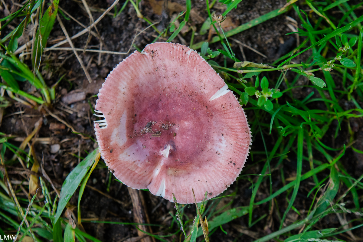

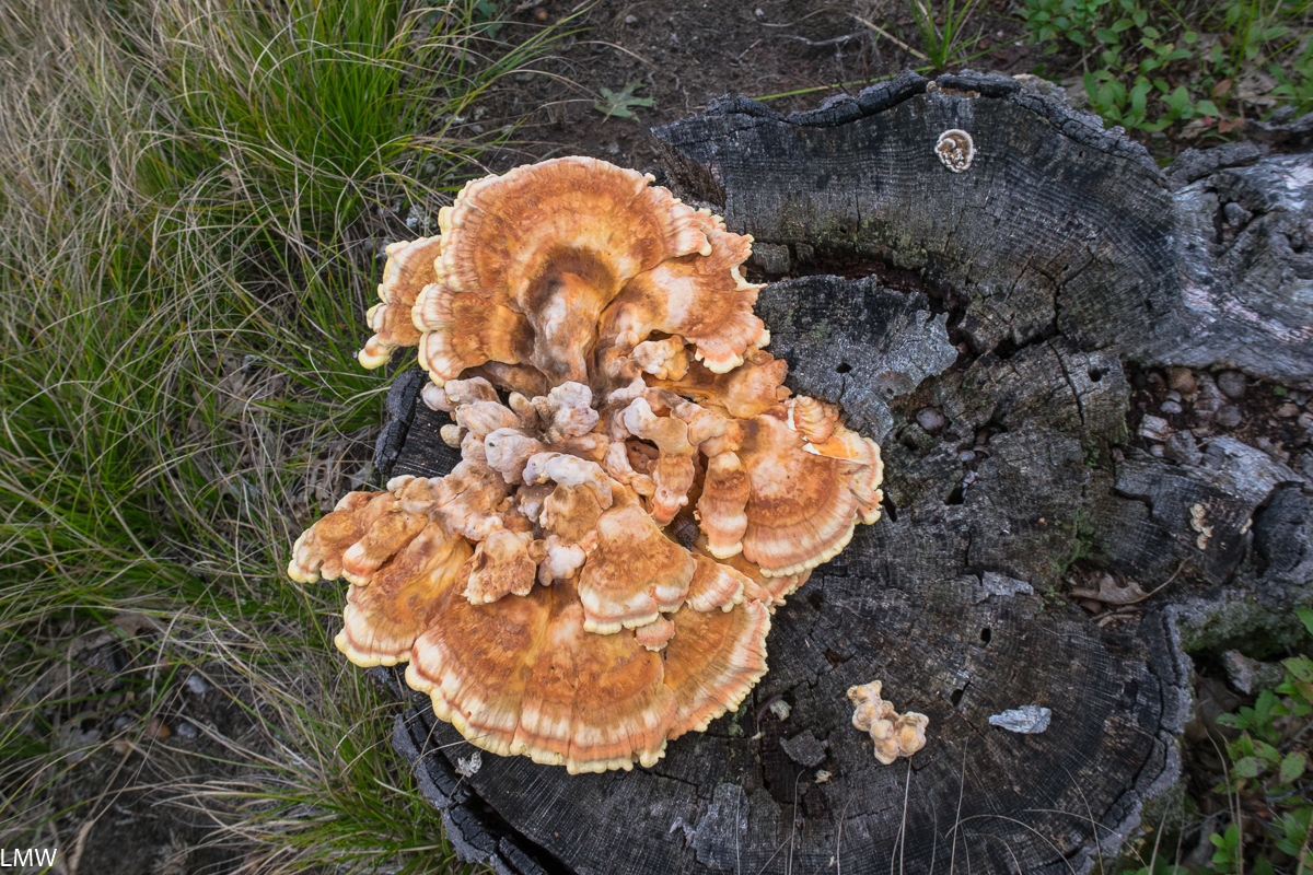
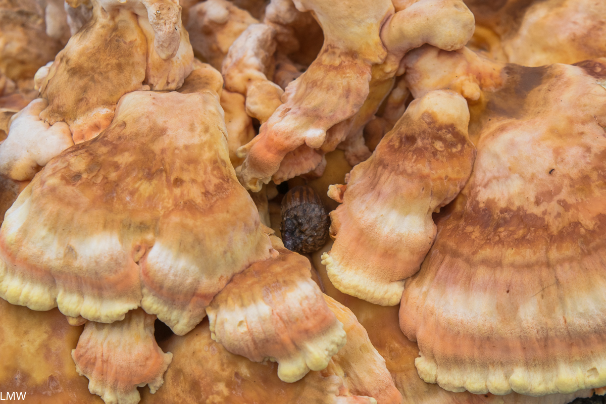
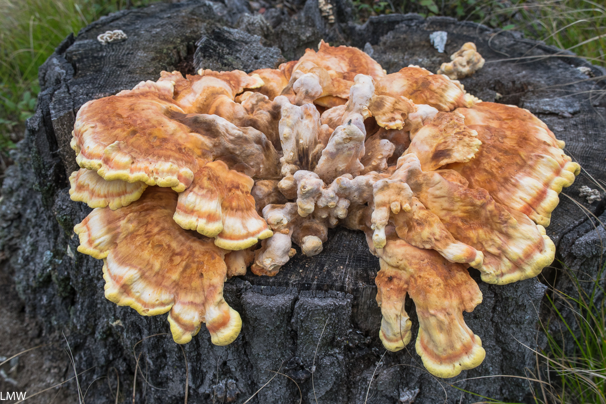
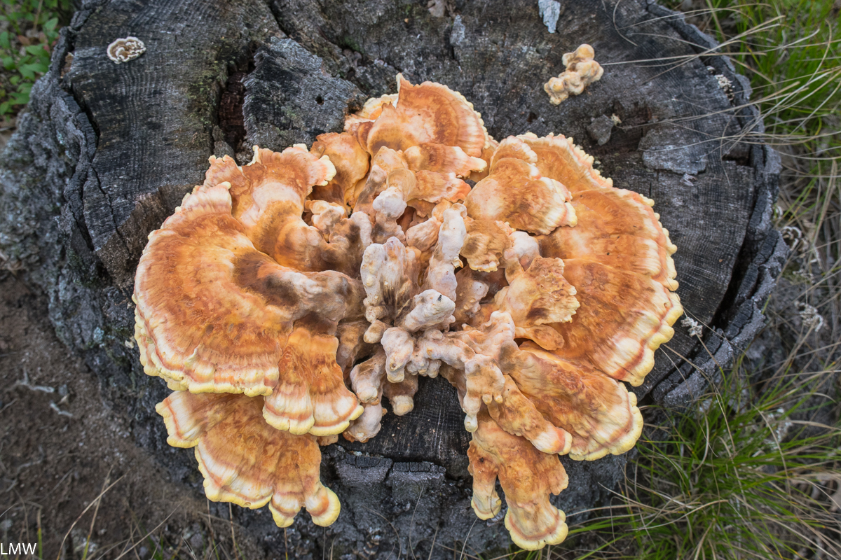


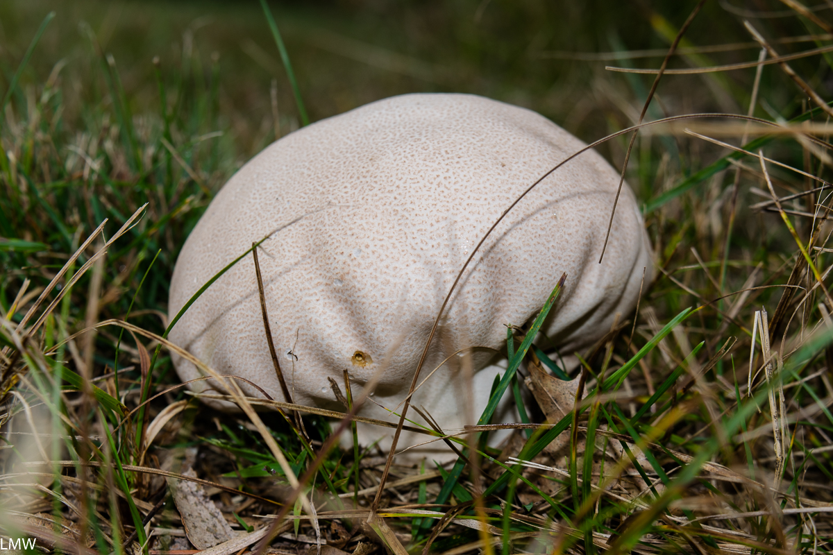


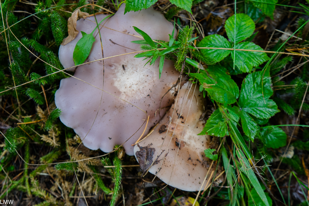


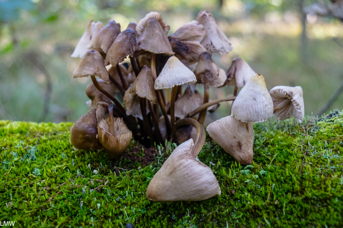
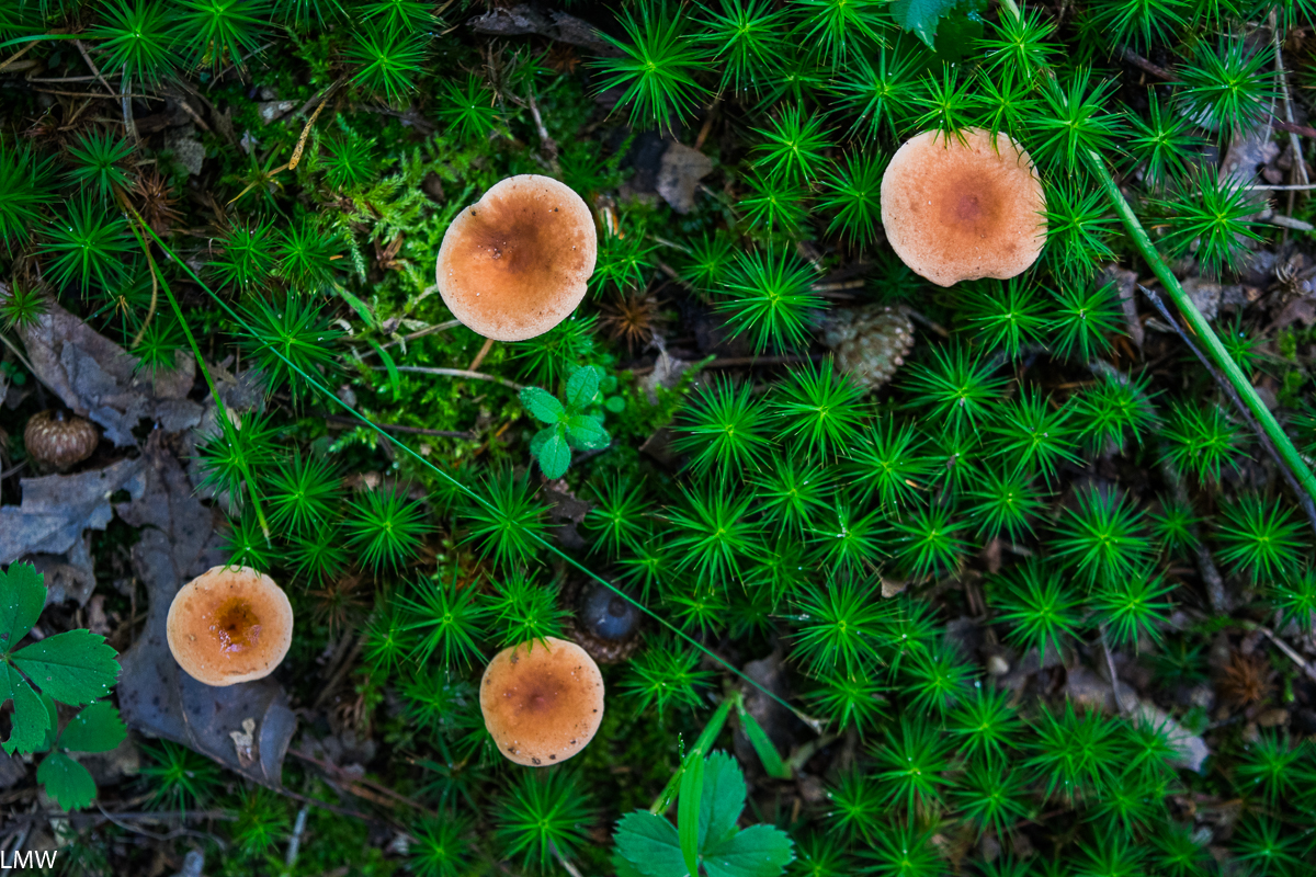
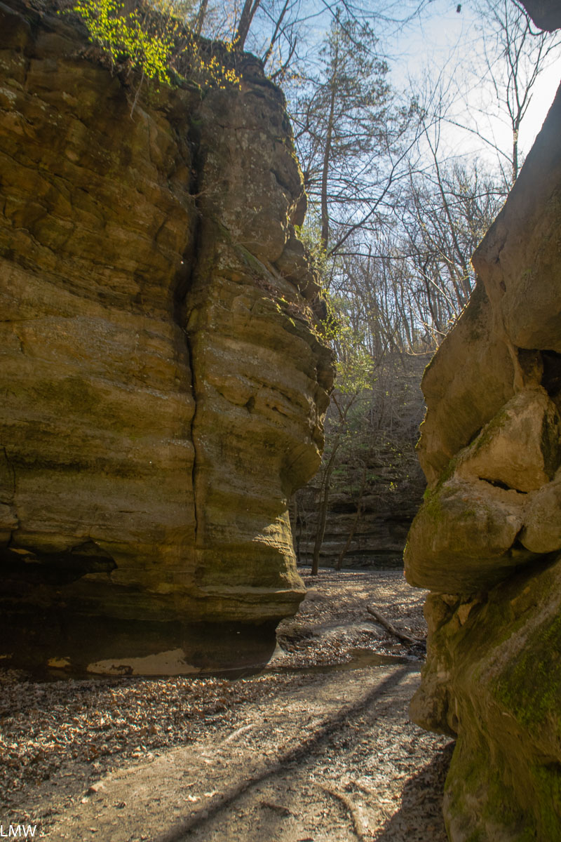
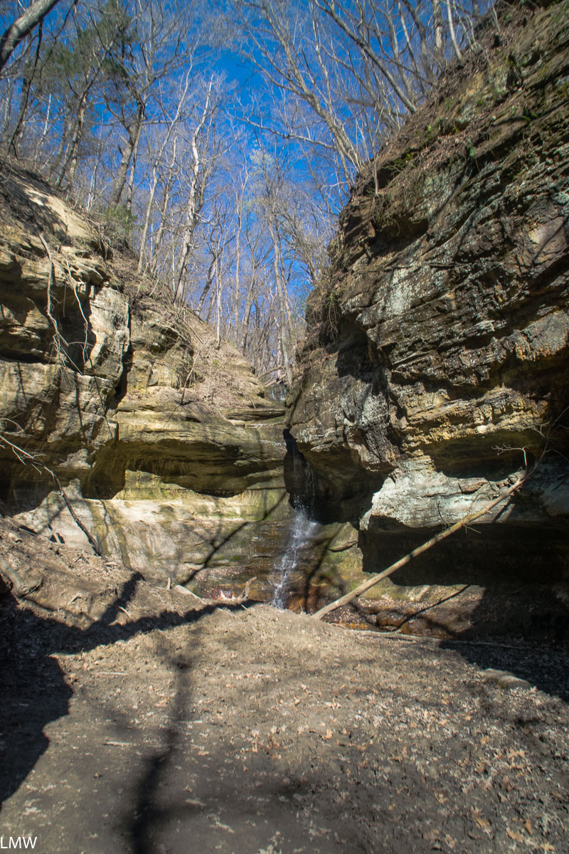
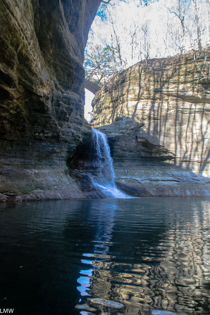
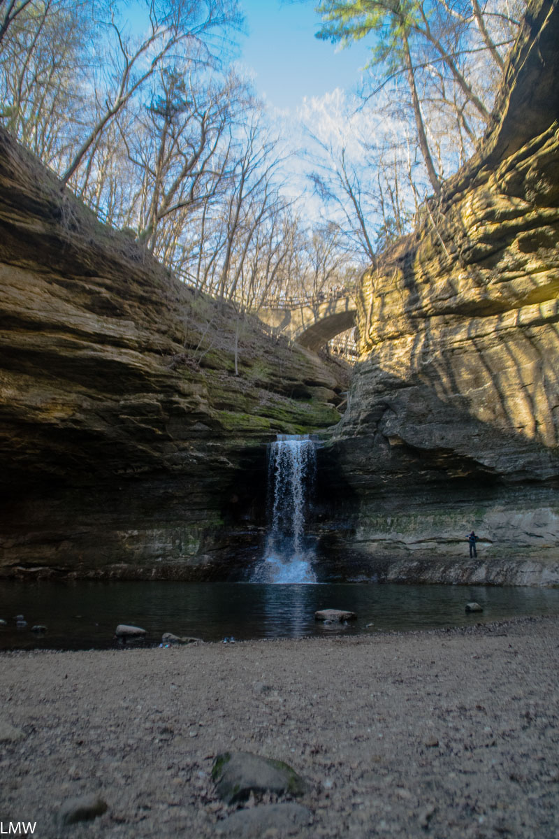
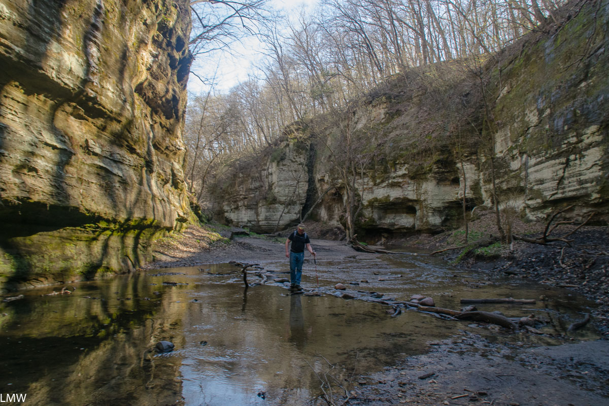
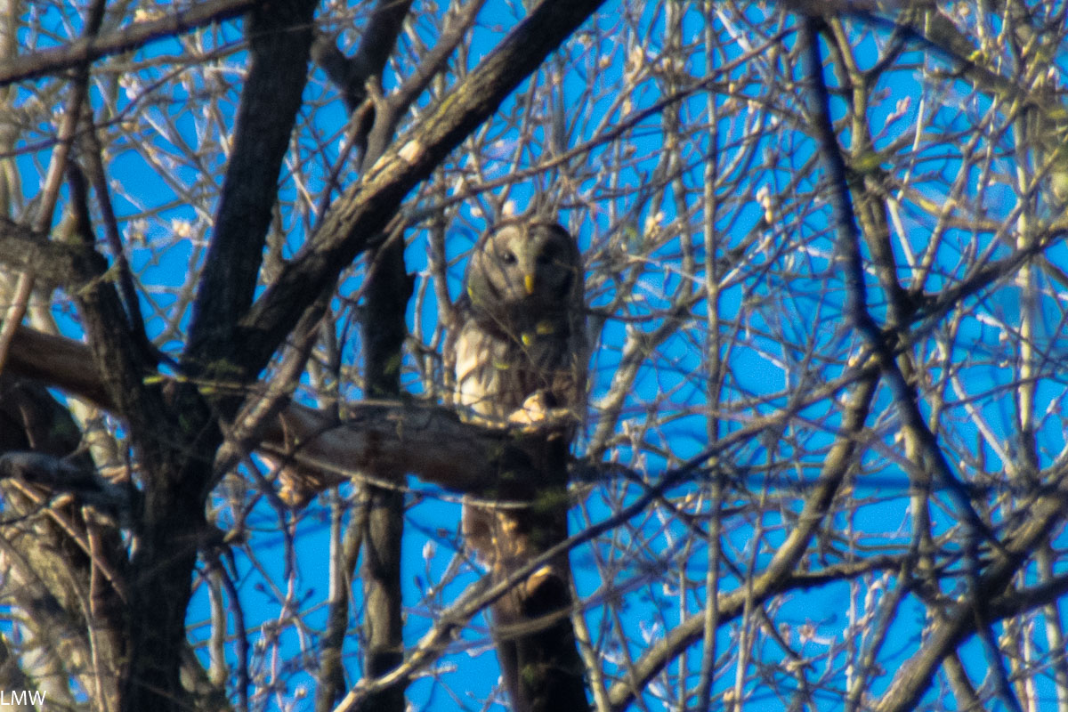
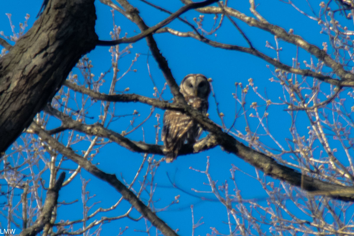
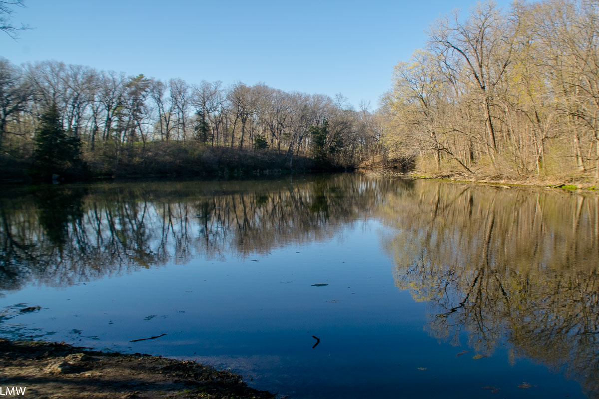
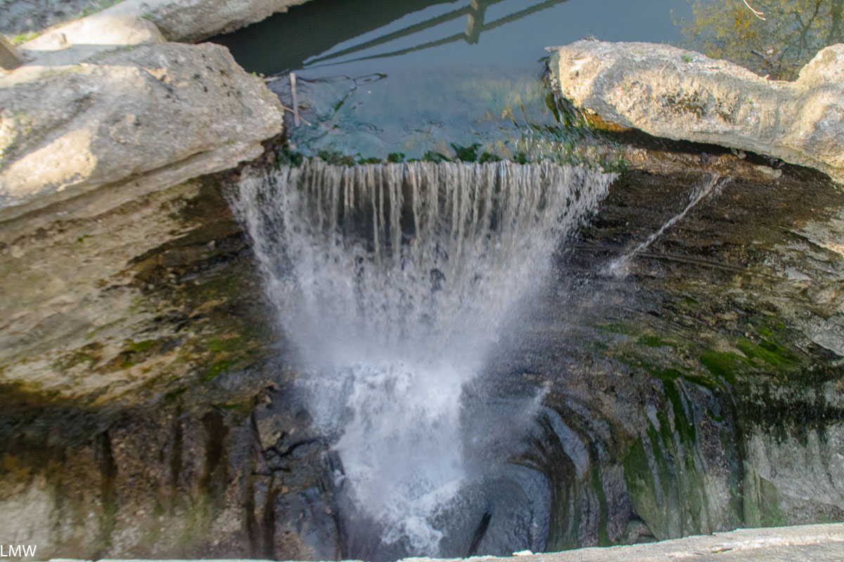
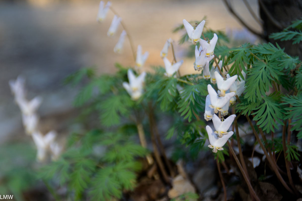
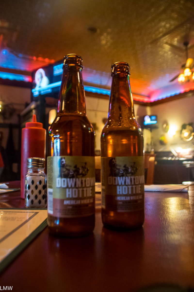